Saba travel guide
About Saba
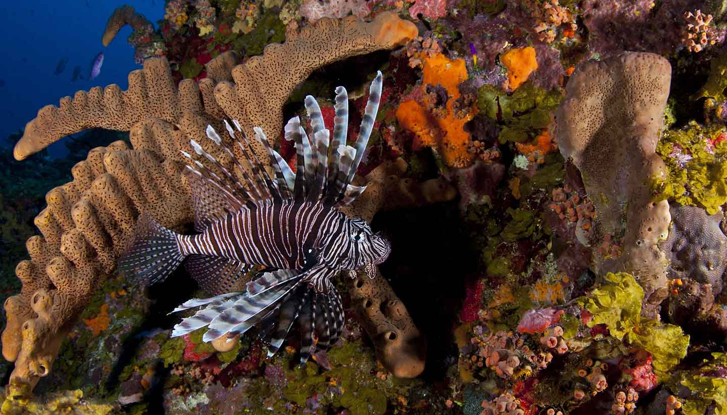
Saba sits majestically at the peak of a submerged extinct volcano. As such, the island abounds with stunning vistas of dramatic cliff faces and spectacular rocky shorelines. With only one road ('The Road') and a population of less than 1,500, Saba is the most unspoilt island of the former Netherlands Antilles, and the superb preservation of the island's unique ecosystem has earned it the nickname of 'The Unspoiled Queen'.
In fact, until 50 years ago, Saba was a secluded oasis, having neither an airport nor a sheltered harbour. There are four villages, which until recently were only connected by thousands of steps cut into the rock. A road now links the airport with the island's capital, The Bottom. The Bottom is situated 250m (820ft) above the ocean on a plateau surrounded by volcanic domes.
Saba, a special municipality of The Netherlands, was a member of the Netherland Antilles until it was dissolved on 10 October 2010.
Key facts
13 sq km (5 sq miles).
1947 (CBS estimate 2016).
153.8 per sq km.
The Bottom.
Under the direct administration of the Netherlands.
King Willem-Alexander since 2013, represented locally by Governor Jonathan Johnson since 2008.
Prime Minister Mark Rutte since 2010, represented locally by Kingdom Representative Gilbert Isabella since 2014.
Travel Advice
Check separate travel advice pages for advice on travel to the constituent countries and special municipalities in the Dutch Caribbean.
Before you travel
No travel can be guaranteed safe. Read all the advice in this guide. You may also find it helpful to:
- see general advice for women travellers
- read our guide on disability and travel abroad
- see general advice for LGBT+ travellers
- read about safety for solo and independent travel
- see advice on volunteering and adventure travel abroad
Travel insurance
If you choose to travel, research your destinations and get appropriate travel insurance. Insurance should cover your itinerary, planned activities and expenses in an emergency.
About FCDO travel advice
The Foreign, Commonwealth & Development Office (FCDO) provides advice about risks of travel to help you make informed decisions. Find out more about FCDO travel advice.
Get travel advice updates
Sign up to get email notifications when this travel advice is updated.
Follow FCDO:
This information is for people travelling on a full ‘British citizen’ passport from the UK. It is based on the UK government’s understanding of the Netherlands’ current rules for the most common types of travel.
The authorities in the Netherlands set and enforce entry rules. If you’re not sure how these requirements apply to you, contact the Netherlands Embassy in the UK.
Passport validity requirements
The Netherlands follows Schengen area rules. Your passport must:
-
have a ‘date of issue’ less than 10 years before the date you arrive – if you renewed your passport before 1 October 2018, it might have a date of issue that is more than 10 years ago, making it invalid for entry to the Schengen area
-
have an ‘expiry date’ at least 3 months after the day you plan to leave the Schengen area (the expiry date does not need to be within 10 years of the date of issue)
Check with your travel provider that your passport and other travel documents meet requirements. Renew your passport if you need to.
You will be denied entry if you do not have a valid travel document or try to use a passport that has been reported lost or stolen.
Dual nationals
When returning to the UK, British citizens must carry a valid British passport or certificate of entitlement. See Dual citizenship.
Visa requirements
You can travel without a visa to the Schengen area, which includes the Netherlands, for up to 90 days in any 180-day period. This applies if you travel:
- as a tourist
- to visit family or friends
- to attend business meetings, cultural or sports events
- or for short-term studies or training
The requirements for working in the Netherlands are different.
If you are travelling to other Schengen countries as well, make sure your whole visit is within the 90-day limit. Visits to Schengen countries within the previous 180 days before you travel count towards your 90 days. If you overstay the 90-day visa-free limit, you may be banned from entering Schengen countries for up to 3 years.
Read about entry processes if you live in the Netherlands.
Staying longer than 90 days in a 180-day period
To stay longer, you must meet the Dutch government’s entry requirements. Check which type of visa or work permit you need on the Dutch government website.
If you’re in the Netherlands with a residence permit or long-stay visa, this does not count towards your 90-day visa-free limit.
New Schengen entry requirements
The European Union’s (EU) new Entry/Exit System (EES) is now being implemented across the Schengen area.
This means that when you travel into the Schengen area for short stays, you may need to register your biometric details, such as fingerprints and a photo. There is no cost for EES registration.
On your first visit into a Schengen country, you may be asked to register your details at a special booth before proceeding to the immigration desk. Follow directions from your travel operator or the staff at your port of entry. You may also need to provide either your fingerprint or photo when you leave the Schengen area. Children aged 11 or younger will not have their fingerprints scanned but can be required to have their photo taken.
You do not need to take any action before you arrive at the border on entry to the Schengen area, but EES may take each passenger extra time to complete so be prepared to wait longer than usual at the border and to allow more time for immigration controls when you depart the Schengen area.
EES is replacing the previous system of manually stamping passports when visitors arrive in the Schengen area for short stays. You may be asked to input biometric details every time you enter or exit.
If you enter the Schengen area through the Port of Dover, Eurotunnel at Folkestone or Eurostar at St Pancras International, any information will be taken at the border before you leave the UK.
Your digital EES record is valid for 3 years.
Read more information on the EU Entry/Exit System and to understand which countries are in the Schengen area.
If you are long-term resident in a Schengen country, you are exempt from EES in all Schengen countries. The full list of EES exemptions is on the EU’s official Travel Europe website.
Temporary border controls
Netherlands has introduced additional entry checks until 8 June 2026. Checks may be carried out on major roads leading into Netherlands, international trains and on intra-Schengen flights. See information from Royal Netherlands Marechaussee.
Border controls at Germany’s borders
A temporary reintroduction of border controls are currently in place at Germany’s borders. If you are planning to enter Germany from Netherlands, see information from The Federal Ministry of the Interior and Community.
Border controls at Belgium’s borders
Belgium has introduced additional entry checks until December 2025. Checks may be carried out on major roads leading into Belgium, motorway car parks, international bus services, international trains and on intra-Schengen flights. Checks may involve verifying travel documents and identification, as well as screening for illegal substances. In Belgium you must carry your passport with you at all times.
Vaccine requirements
For details about medical entry requirements and recommended vaccinations, see TravelHealthPro’s Netherlands guide.
Customs rules
There are strict rules about goods you can take into or out of the Netherlands. You must declare anything that may be prohibited or subject to tax or duty.
Taking food and drink into the Netherlands
You cannot take meat, milk or products containing them into EU countries. There are some exceptions such as powdered baby milk, baby food and special foods or pet feed required for medical reasons.
Taking money into the Netherlands
Declare cash or travellers cheques if the value is 10,000 euros or more. You will get a certified declaration to show you brought it in with you. If you do not, your money could be seized when you leave.
Terrorism
There is a high threat of terrorist attack globally affecting UK interests and British nationals, including from groups and individuals who view the UK and British nationals as targets. Stay aware of your surroundings at all times.
UK Counter Terrorism Policing has information and advice on staying safe abroad and what to do in the event of a terrorist attack. Find out how to reduce your risk from terrorism while abroad.
Terrorism in the Netherlands
Terrorists are likely to try to carry out attacks in the Netherlands.
Attacks could be indiscriminate, including in places visited by foreign nationals. You should remain aware of your surroundings, keep up to date with local media reports and follow the advice of local authorities.
Crime
Protecting your belongings
Pickpocketing and bag-snatching are common, particularly in central Amsterdam and around Amsterdam Central Station. Thieves often operate in gangs on the trains and trams to and from Schiphol airport and Central Station. One thief distracts you while another steals your bag. Sleeping on trains can make you an easy target.
Thieves enter restaurants on the pretext of selling something or looking for someone. They steal bags while people are distracted.
You should:
- keep sight of your luggage and belongings – especially when checking into hotels
- keep valuables securely on your person
- avoid hanging bags or jackets on the back of a chair in restaurants
- avoid falling asleep in public or on public transport
Fake police scams
Amsterdam police have warned of criminals using false police identities to trick tourists into handing over cash and credit cards. They will usually say that it is part of an investigation into counterfeit money or false credit cards. Be very cautious about any approaches.
Genuine plain-clothes police will rarely carry out this type of inspection. Dutch police do not have shiny badges, which the fake police sometimes present as ID.
Call 0900 8844 to contact the nearest police station if you are unsure whether a police person is genuine.
Drug sellers
Avoid confrontation with anyone offering you drugs. Stay away from quiet or dark alleys, particularly late at night.
Drink spiking
There is a risk of drink spiking, particularly for young women and solo travellers. Do not leave your drink unattended. If you are in a group, make sure you stay together.
If you think your drink has been spiked, seek immediate medical help and contact the police.
Organised crime
There are regular incidents of violent crime among organised crime gangs involved in drug trafficking, particularly in Amsterdam, Rotterdam, The Hague, and other large cities. Confrontations between rival gangs have led to violent incidents including shootings, stabbings, and use of homemade explosives.
The risk mostly affects those involved in drug crime, but there is always the risk of being in the wrong place at the wrong time. Remain vigilant if you suspect illegal activity. Follow the advice of local authorities.
Laws and cultural differences
Personal ID
Anyone aged 14 or over must always be able to show identification. British nationals should use their passport as ID. Dual nationals can show a Dutch driving licence, Dutch passport or identity card.
For people aged 16 or over who fail to comply with the requirement to identify themselves, the fine is 100 euros. For persons aged 14 and 15, the fine is 50 euros.
Illegal drugs
The Netherlands has a reputation for being tolerant on the use of ‘soft drugs’, such as cannabis. However, drug use is only tolerated in designated premises in the major cities. Buying or possessing prohibited drugs and substances outside of designated areas, including when transiting through airports, is illegal and can result in a prison sentence.
Airports in Netherlands have excellent technology and security for detecting illegal items. This is also used to scan the baggage of transiting passengers.
Smoking soft drugs in public places is illegal. There are specific cafés where it is legal to purchase and use cannabis in limited quantities and under strict conditions.
The sale of dry and fresh psychoactive mushrooms is illegal. However, the truffle (sclerotium) form of psychoactive (psilocybin) mushrooms is not covered under Dutch law (Opium Act) and is still sold in regulated ‘smart shops’.
Be extremely careful as mixing alcohol, cannabis and wild mushrooms can be fatal.
Canal laws and dangers
Every year people drown in the canals of Amsterdam and in canals elsewhere in the Netherlands. The majority of drownings happen after heavy drinking or smoking cannabis. Take care when walking beside canals.
If police catch you swimming in the Amsterdam canals, they will fine you 160 euros. They will also fine you for urinating in the canals.
Transport risks
Road travel
If you are planning to drive in the Netherlands, see information on driving abroad and check the rules of the road in the RAC’s Netherlands guide. The guide lists driving regulations and other legal requirements you need to be aware of.
You can drive in the Netherlands on a UK driving licence. Always carry your:
- driving licence
- insurance documents
- vehicle documents
- photo ID such as a passport or residence permit
If you are driving a vehicle that does not belong to you, you may need written permission from the registered owner. You are not allowed to drive on a provisional licence.
Check if you need a UK sticker to drive your car outside the UK.
If you’re living in the Netherlands, check the driving requirements for residents.
Driving regulations
Traffic offences can carry heavy, on-the-spot fines. If you pay a fine, always ask for a receipt.
Watch out for trams. They have priority over other traffic. You must stop if a tram or a bus stops in the middle of the road to let passengers on and off.
Speed cameras, speed traps and unmarked vehicles are widely used. Motorway speed limits can vary. You must follow overhead illuminated lane indicators when in use.
Look out for cyclists and mopeds, who have right of way over motor vehicles and often ignore road traffic rules and red lights.
Pedestrian safety
Be on the look-out for cyclists, mopeds and trams when crossing roads, especially on zebra crossings. If you do not use marked crossings on roads, you could be fined for jaywalking.
Cycle paths are busy and cyclists ride at speed.
Before you travel check that:
- your destination can provide the healthcare you may need
- you have appropriate travel insurance for local treatment or unexpected medical evacuation
This is particularly important if you have a health condition or are pregnant.
Emergency medical number
Dial 112 and ask for an ambulance.
Contact your insurance or medical assistance company quickly if you’re referred to a medical facility for treatment.
Vaccine recommendations and health risks
At least 8 weeks before your trip:
- check the latest vaccine recommendations for the Netherlands
- see where to get vaccines and whether you have to pay on the NHS travel vaccinations page
See what health risks you’ll face in the Netherlands, including biting insects and ticks.
Medication
The legal status and regulation of some medicines prescribed or bought in the UK can be different in other countries.
TravelHealthPro explains best practice when travelling with medicines.
Healthcare in the Netherlands
FCDO has a list of medical providers in the Netherlands where some staff will speak English.
Health insurance cards
To get medically necessary state healthcare in the Netherlands, you need a Global Health Insurance Card (GHIC) or a European Health Insurance Card (EHIC).
The NHS’s getting healthcare abroad webpage has details about:
- how to apply for a GHIC
- how to get temporary cover if you lose your card or it does not arrive in time
- who qualifies for a new EHIC instead of a GHIC
- what treatment counts as medically necessary
A GHIC or EHIC is not an alternative to travel insurance. You may have costs your GHIC or EHIC does not cover, including:
- changes to travel and accommodation bookings
- additional standard costs for treatment
- medical repatriation to the UK
- treatment that is ruled non-urgent
- private healthcare
- private clinics
- prescription charges
There is also guidance on healthcare if you’re living in the Netherlands.
Travel and mental health
Read FCDO guidance on travel and mental health. There is also guidance on TravelHealthPro.
The Foreign, Commonwealth & Development Office (FCDO) cannot provide tailored advice for individual trips. Read this travel advice and carry out your own research before deciding whether to travel.
Emergency services in the Netherlands
Telephone: 112 (ambulance, fire, police)
Contact your travel provider and insurer
Contact your travel provider and your insurer if you are involved in a serious incident or emergency abroad. They will tell you if they can help and what you need to do.
Refunds and changes to travel
For refunds or changes to travel, contact your travel provider. You may also be able to make a claim through insurance. However, insurers usually require you to talk to your travel provider first.
Find out more about changing or cancelling travel plans, including:
- where to get advice if you are in a dispute with a provider
- how to access previous versions of travel advice to support a claim
Support from FCDO
FCDO has guidance on staying safe and what to do if you need help or support abroad, including:
- finding English-speaking lawyers, funeral directors and translators and interpreters in the Netherlands
- dealing with a death in the Netherlands
- being arrested in the Netherlands
- getting help if you’re a victim of crime
- what to do if you’re in hospital
- if you are affected by a crisis, such as a terrorist attack
Contacting FCDO
Help abroad
See how to get help from the UK government abroad including in an emergency.
Help in the UK
You can call FCDO in London if you need urgent help because something has happened to a friend or relative abroad.
Telephone: 020 7008 5000 (24 hours)
Get travel advice updates
Sign up to get email notifications when this travel advice is updated.
Follow FCDO:
Risk information for British companies
The Overseas Business Risk service offers information and advice for British companies operating in the Netherlands on how to manage political, economic, and business security-related risks.